
by Guy Entwistle
This article looks to give a brief synopsis on a Masters Thesis produced this summer for the Maritime Archaeology programme at the University of Southampton.
‘Coasts are dynamic, but historic assets are fixed’ (Murphy 2009:9)
Introduction
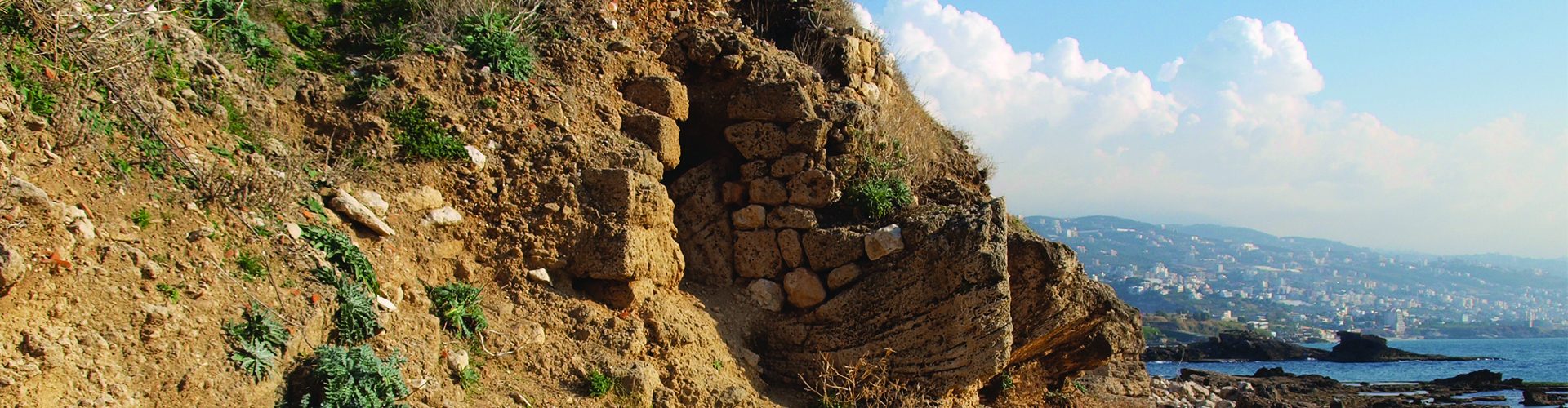
The thesis examined the threats posed by natural and anthropogenic climate changes to the coastal site of Siraf, Iran. The site is located on the Western coast of Iran on the Persian Gulf (52°18ʹ 30ʺ to 52°21ʹ 30ʺ E and 27°39ʹ 00ʺ to 27°41ʹ 00ʺ), a semi-enclosed body of water with a total area covering roughly 226 000 km2 with an average water depth of 35 m; the basin is connected to the Indian Ocean by way of the Gulf of Oman and the Straits of Hormuz (Fig 1; Beni et al 2021:2; Liao 2016:19).
Coastlines bridge the gap between maritime and terrestrial activity, in turn creating areas of increased connectivity and social interaction. The site was chosen as a point of interest because of its extensive and diverse infrastructure spanning along a 1 KM stretch of coastline, as well as its natural vulnerability given it is located on a sandy coastline with a steep mountainous rocky backdrop (Ketabdari and Karimi 2018:7). The wealth of its historical significance in religious, military, social, political and economic matters created an important location with invaluable cultural heritage. The port city’s infrastructure is still present (see Fig. 1 & Table 1) and is listed on the ‘Tentative List’ of World Heritage Sites by UNESCO.
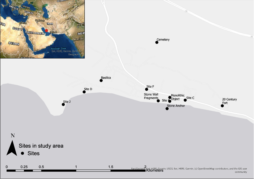
| Site | Description | Period of Construction |
| B | Congregational Mosque | Early 9th Century |
| C | Bazaar | Early 9th Century |
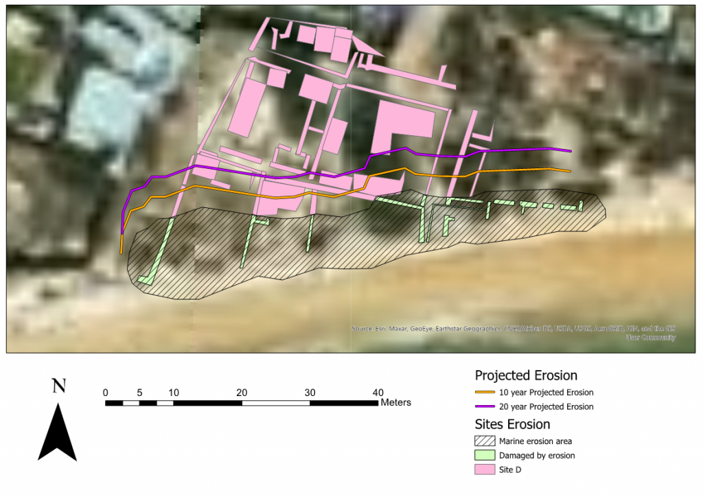
| D | Potters Quarter | 10th Century |
| F | Residential Quarters | Late 9th Century – Mid 11th Century |
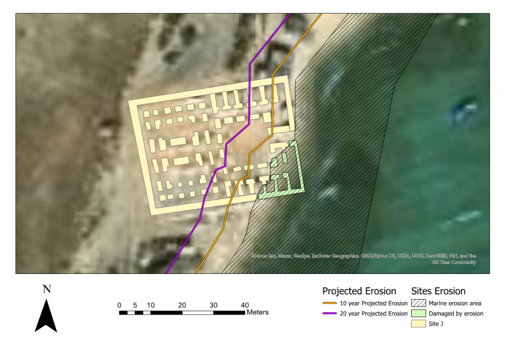
| J | Military Complex | 10th Century |
| G | Shrine | 13th – 15th Century |
| K | Palatial Residence | Unknown |
| O | Monumental Cemetery | Unknown |
| L & N | West Gate, Basilica & Shoreline Sea Wall | Late 9th Century |
The effects of natural climate change, enhanced by the accelerated effects of anthropogenic climate change, have never been a more prominent issue. This project was researched and written at a time of flash flooding across Europe as well as the hottest temperatures recorded in the Northern Hemisphere (Kreienkamp et al 2021). These events, in conjunction with the increasing frequency of damaging storms and hurricane force winds are the result of a changing climate. Coastal communities are often the first to feel the impact of such events, resulting in the eroding and destruction of their past and present.
With an increasing threat comes an increasing urgency in understanding how to manage such issues. Action within the UK can be seen through the continuous work performed by CITiZAN (Coastal and InterTidal Archaeology), Cherish (Climate, Heritage and Environments of Reefs, Islands and Headlands) and SCAPE (Scottish Coastal Archaeology and the Problem of Erosion). Within the MENA (Middle East and North Africa) region, management of heritage at threat can be seen through the work done by the MarEA project and EAMENA (Endangered Archaeology in the Middle East and North Africa). While archaeological research into the damage and threat posed to maritime heritage is becoming increasingly recognised in bodies of research (see recommended reading), the global action towards the ensuing issues presented by the changing climate can be observed via the COP26 conference held at the time of writing in Glasgow, Scotland.
Brief History and the Contemporary Region
This section was intentionally kept brief, however, more information is included in the recommended reading list.
The site of Siraf spanned two periods dating roughly from 224 AD to the decline in c.14th Century AD. The first stage, ‘Sasanian Period’, dated from 224 AD to the 6th Century AD. During this period Siraf existed as a commercial port. Despite limited literary sources, material evidence suggests that Siraf was likely an entrepot to East Africa, India, Sri Lanka and potentially China. The site also includes evidence of naval activity through the fortress found under the Congregational Mosque (Site B; see Fig. 1) and two examples of naval activity when attacking Bahrain (c.224 – 241 A.D; Whitehouse 2009:9) and the expedition to Yemen to fight Ethiopian settlers (570 – 575 A.D; Whitehouse & Wilkinson 1973:44).
The Seventh and Eighth Centuries are considered a period of transition and realignment. A lack of literary and archaeological evidence suggests a dip in international importance (Ricks 1970: 343). However, stability ensued with the introduction and establishment of Islam in the region, providing an alignment of religious and ethical morals in West Asia and East Africa, which led to the two most prosperous centuries in the history of Siraf. The Ninth and Tenth Centuries AD produced the most commercially successful period for the city with vast economic growth and stability. Established trade routes with East Africa and the Maritime Silk Road connecting to China created an extensive map of connectivity. This period also produced lavish building projects, such as the Congregational Mosque, built 803 – 825 AD (Whitehouse 1974:5; see table 1).
During its history Siraf played a significant role, operating in the Indian Ocean and beyond to export and import goods such as spices, cotton, cloth, perfumes, ceramics and wood (Ricks 1970: 351). The site experienced great prosperity, a contemporary account from Ibn Hauqal, detailed merchants spending 30,000 dinar on building private homes, equal to 127.5KG of gold (1965: 284-88; Whitehouse 2009: 13). Abbasid Caliph al-Muqtadir, ruler of Siraf in the early 10th century, is said to have earned 2,530,000 dinar from levied goods entering the city, equivalent to 10,752.5KG of gold and indicative of the wealth and operations of the port city (Ibn al-Bakhi 1962: 136-7).
The modern-day region has removed itself from the status of a once vibrant and bustling commercial import/export city. Siraf is now home to a population of 7,000 (data.worldbank.org). Interest in the Bushehr Province has moved north and south of the site by the South Pars oil and gas reserves, which has brought Iran commercial wealth and prosperity.
Aims and Method
The aim of the project was to ascertain the threats to Siraf posed by natural and anthropogenic climate change, map the threats using GIS and then discuss possible management solutions. The study looked at wind direction, wind power and wave energy between 1980-2010, based on two papers from Kamranzad (2013; 2018). These studies established that 12% of waves that hit the Sirafi coastline were 1m and above, placing them in the ‘Destructive’ category of wave (Reimann et al 2018:8). Wave energy does not look to increase throughout the century by any substantial amount when observing RCP (Representative Concentration Pathways) 4.5 and 8.5 but is already causing significant damage at the current rate (Goharnejad et al 2020:28). Sea-level rise, average annual temperatures and erosion rates will all increase dramatically in the immediate years, with the statistics showing greater figures emerging as the century proceeds. This research produced the prediction of future erosion rates based on past and existing data sets to present a visual representation on the loss of coastline.
Sea Level Rise
- Year 2050 2100
- RCP 4.5 14-34 cm 34-76 cm
- RCP 8.5 24-41 cm 58-172 cm
Iran is home to three desert regions, all of which may become uninhabitable within the century (Vaghefi 2019:1). Siraf finds itself within a ‘hot coastal dry’ region. The plateau in which it is located is very thin and is abruptly met by the Zagros Mountains. The Siraf plain, sits upon an alluvial fan which is created when a water source (Persian Gulf) interacts with a mountain range (Zagros). The result being a plain made of small sediment such as silt, gravel and sand. Siraf falls into the category of ‘Low Coastal Elevation Zone’ (LECZ), this is defined as a coastline that sits below 10m above sea level, Siraf is located no higher than 4m. The geological nature of the site, formed during the Paleozoic to Quaternary period, combined with the LECZ and the narrow plain puts the whole city of Siraf at a realistic risk of erosion.
Extreme Weather
The temperature in the Bushehr Region is predicted to increase. The average number of days where a maximum temperature is recorded per annum is predicted to increase by 2.5 times in the proceeding 25 years. The rise in temperature is further accentuated when considered in tandem with the droughts experienced in the region, a part of the world that already receives less than a third of the world’s average precipitation (Gholami et al 2020:5).
The Bushehr Province is at great risk of higher frequency of extreme weather events. In recent years the province has been affected by flash floods. The region experienced the second highest recording of rainfall in Iran between the years 2015 – 19, 230mm of rainfall in 3 days. For comparison, the province that received the most rainfall, Firooz Abad, received 300mm in 6 days over a land mass that covers triple that of the Bushehr province. The climatic conditions, coupled with the geomorphology of Siraf are indicative of a coastline at grave risk of accelerated erosion.
Coastal Erosion
An area of more than 1000m2 including shops, a Mosque and a Hammam.
Eroding at a rate 2m per 10 years.
Coastal erosion is the result of anthropogenic and natural environmental changes resulting in the imbalance of coastal processes via the alteration of coastal dynamic action. High energy, low frequency marine events such as storm waves and tsunamis act as an integral part of the natural sedimentary process, longshore drift proving the most prevalent form of wave erosion (Trakadas 2020:15). The Persian Gulf was always considered a haven from extreme oceanic activity. However, the tsunami that struck Dayyer in 2017, taking the lives of five people with waves measuring 3 metres, is representative of the wave patterns emerging from increasing and sustained climate change (Heidarzadeh 2019).
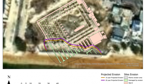
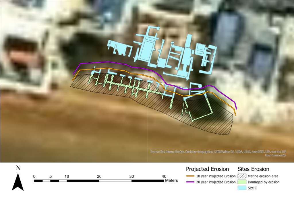
Data was collated from literary sources to provide erosion/accretion rates for the coastline of Siraf between years 1973-2016 (Pourkerman 2018). The maps were created to provide a visual representation of the destruction of historic infrastructure. The maps detail the erosion already observed, as well as future projections for the years 2026 and 2036. The maps offer a visual representation of loss to the archaeological site of Siraf. Erosion happens at a rate often not visible to the naked eye, and likely presumed as insignificant at small time scales, therefore, the future projections were created to highlight the longterm impact of erosion.
Located on the western edge of the city to limit risk from fires and pollution.
Flourished during the 10th Century, producing a wide range and small and large products. Eroding at a rate of 3.2m per 10 years.
Sits upon the most westerly part of the city, on a headland.
Placed in a strategic position, controlling the bay and the city walls. Constructed in the 10th Century. Eroding at a rate of 8m per 10 years.
Discussion
Integrated Coastal Zone Management (ICZM) is a method adopted by governments worldwide to ensure the health and safety of shorelines and coastal regions. Iran’s ICZM is ran by the Ports and Maritime Organisation (PMO) and is still in relative infancy. However, this is not a fault of Iran alone and a recent paper has called for the inclusion and consideration of heritage in the MENA region through the legislative initiative used to protect marine habitats, Marine Protected Areas (Breen et al 2021). It appears that so often there lies in the issue when considering heritage at risk on coastlines. The hierarchical order of priorities placed upon coastal inhabitants, objects and infrastructure finds heritage wavering, often without consideration, when compared to socio-economic development and preservation of natural habitats. It is not suggested that heritage supersedes said notions but rather that consideration is given to tangible infrastructure and objects when creating ICZMs, Shoreline Management Plans and legislation. A review of ICZMs found that such initiatives rarely surpass the implementation stage (Eger 2021:1-9). The vast wealth of history that is encompassed within the bricks and mortar that make Siraf is in the process of washing away with very few mitigations being considered.
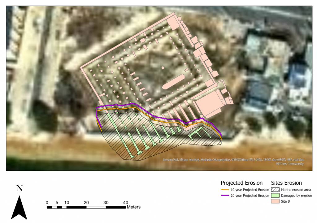
The Mosque certainly underwent 3 building phases, potentially 5.
The Minaret is believed to be one of the earliest in the Moslem world.
Eroding at a rate of 2m per 10 years
Creating hard defences to protect the coastline were explored but, the cost is large in construction and maintenance and the defences create issues further along the coastline. Hard defences (groynes, sea walls, offshore breakwaters and artificial headlands) also create issues for natural habitats and disrupt the natural shoreline process. The soft approach, beach nourishment, stabilisation and bioengineering has proven to be very effective in managing coastal erosion, especially when used as the main line of defence alongside a secondary hard approach technique (ibid). The caveat to this being the short lifespan of soft approaches.
Archaeology has adopted the method of recording sites at threat of the effects of climate change. Researchers and heritage managers have employed large-scale monitoring of coastlines, tracking recession and advancement, investigating the patterns of erosion, and assessing the possible relationship with the preservation of in situ materials and sites (Andreou 2017:198). This is achieved using remote sensing from satellite, airborne and ground based tools such as satellite imagery, LiDAR, aerial photography, ground penetrating radar, magnetometry and resistivity equipment. Away from the desk this method also utilises the tireless enthusiasm found within members of the public through public engagement schemes. However, such engagements are more common within western Europe. Examples can be found at SCAPE (Scottish Coastal Archaeology and the Problem of Erosion), CITiZAN (Coastal and InterTidal Archaeology Network), DRASSM (Departmente des recherches Archeologiques Subaquatiques et Sous-Marines) and ALeRT (Archéologie, Littoral et Réchauffement Terrestre).
It is concluded that preservation by record as a form of mitigation and management provides the most effective tool to combat the loss of coastline heritage. While this process does leave sites such as Siraf at the mercy of the elements, which appear to increase at an alarming rate given the nature of worsening climatic conditions, it does create a digital database of archaeological sites that can be processed and updated when deemed necessary and would not face the erosive processes of coastlines.
Reading Recommendations
Coastal Sustainability
Brimblecombe P, Grossi CM, Harris I (2011) Climate change critical to cultural heritage. In: Gökçekus H, Türker U, LaMoreaux JV (eds) Survival and sustainability, environmental concerns in the 21st century. Springer, Berlin Heidelberg, pp 91–101
Daire, M.Y., Lopez-Romero, E., Proust, J.N., Regnauld, H., Pian, S., Shi, B., (2012). Coastal changes and cultural heritage: assessment of the vulnerability of the coastal heritage in Western France. Journal of Nautical Archaeology. Vol. 7 (2). PP. 168– 182.
Gomez-Heras, M., Mccabe, S., (2015) Weathering of stone-built heritage: a lens through which to read the Anthropocene. Anthropocene Vol. 11 PP. 1–13
Leissner J, Kilian R, Kotova L et al (2015) Climate for culture: assessing the impact of climate change on the future indoor climate in historic buildings using simulations. Herit Sci 3(38):1–15
Siraf Literature
Whitehouse, D., (2009). Siraf, History. Topography and Environment. Oxford.
- David Whitehouse excavated the site between 1966-73, producing reports each season. Further work has been performed by Khakzad et al, who produced a pilot study published in 2015.All of which are available online. Contemporary literature for the Sasanian Period does not exist, however, work can be found from the Medieval Period and beyond from the likes of al-Balkhi, Ibn Hawqal and Yaqut.
References
Andreou, G. et al. (2017). Integrated methods for understanding and monitoring the loss of coastal archaeological sites: The case of Tochni-Lakkia, south-central Cyprus. Journal of Archaeological Science. Vol 12. PP 197–208
Beni, A. et al. (2021). Climate Change: A Driver for Future Conflicts in the Persian Gulf Region? Heliyon 7
Breen, C., El Safadi, C., Huigen, H., Tews, S., Westley, K., Anderou, G., Vazquez, R.O., Nikolaus, J., Blue, L., (2021) Integrating cultural and natural heritage approaches to Marine Protected Areas in the MENA region. Marine Policy. Vol. 132.
Eger, S.L., de Loe, R.C., Epstein, G., Courtenay, S.C., (2021) A systematic review of integrated coastal and marine management progress reveals core governance characteristics for successful implementation. Marine Policy. Vol. 132
Gholami, D., Jaafari, A., Zenner, E. et al (2020). Vulnerability of coastal communities to climate change: Thirty year trend analysis and prospective prediction for the coastal regions Persian Gulf and Gulf of Oman. Science of the Total Environment.
Goharnejad, H., Nikaein, E., Perrie, W., (2020). Assessment of Wave Energy in the Persian Gulf: An evaluation of the impacts of climate change. Oceanologia. Vol. 63. PP 27-39.
Heidarzadeh, M., Šepić, J., Rabinovich, A. et al. (2020). Meteorological Tsunami of 19 March 2017 in the Persian Gulf: Observations and Analyses. Pure and Applied Geophysics. Vol. 177. PP. 1231–1259
Ibn al-Balkhi. (1962). G. Le Strange and R. A. Nicholson (trans. & eds), Farsnameh. Gibb Memorial Series, N.S. I, London
Ibn Hauqal. (1962). Configuration de la terre (Kitab Surat al-ard). Tr. J. H. Krammers and G. Wiet. Paris
Kamranzad, B., Etemad-Shahidi, A., Chegini, V., (2013). Assessment of wave energy variation in the Persian Gulf. Ocean Eng. Vol. 70. PP. 72—80.
Kamranzad, B., (2018). Persian Gulf zone classification based on the wind and wave climate variability. Ocean Eng. Vol. 169. PP. 604—635.
Ketabdari, M.J., Karimi, M., (2018). Sedimentation and Scoring Analysis. Siraf Methanol Terminal Offshore Export Facilities.
Kreienkamp, F. et al. (2021). Rapid attribution of heavy rainfall events leading to the severe flooding
in Western Europe during July 2021. World Weather Attribution.
Liao, Y.P., Kaihatu, J.M., (2016). Numerical investigation of wind waves in the Persian Gulf: bathymetry effects. Journal of Atmospheric and Oceanic Technology. Vol. 33. PP. 17—31.
Pourkerman, M., Mariner, N., Morhange, C., Djamali, M., Spada, G., et al (2020). Geoarchaeology as a tool to understand ancient navigation in the northern Persian Gulf and the harbour history of Siraf. Journal of Archaeological Science. Elsevier. Vol. 33.
Reimann, L., Vafeidis, A., Brown, S., (2018). Mediterranean UNESCO World Heritage at risk from coastal flooding and erosion due to sea level rise. Nature Communications. Vol. 9.
Trakadas, A., (2020). Natural and Anthropogenic Factors Impacting Northern Morocco’s Coastal Archaeological Heritage. A preliminary assessment. Journal of Coastal Archaeology.
Ricks, T. M., (1970). Persian Gulf Seafaring and East Africa: Ninth-Twelfth Centuries. African Historical Studies 3.2, 339–57
Vaghefi, S. et al. (2019). The Future of Extreme Climate in Iran. Scientific Reports.
Whitehouse, D., (2009). Siraf, History. Topography and Environment. Oxford.
Whitehouse, D. & Williamson, A., (1973). Sasanian Maritime Trade. Iran. Taylor & Francis Ltd. Vol 11. PP 29-49
Digital Resources
Coastal and Intertidal Zone Archaeology Network https://citizan.org.uk/
Scottish Coastal Archaeology and the Problem of Erosion https://scapetrust.org/
Climate, Heritage and Environments of Reefs, Islands and Headlands http://cherishproject.eu/en/
UNESCO https://whc.unesco.org/en/tentativelists/5195/
Maritime Endangered Archaeology https://marea.soton.ac.uk/
Endangered Archaeology in the Middle East and North Africa eamena.org
UN Climate Change Conference ukcop26.org
World Bank Data Population. https://data.worldbank.org/
Departmente des recherches Archeologiques Subaquatiques et Sous-Marines https://archeologie.culture.fr/archeo-sous-marine/en/drassm-unique-and-indispensable-institution
Archéologie, Littoral et Réchauffement Terrestre https://alert-archeo.org/