
By Eva Perez Chirinos De Andres
Introduction
Oman’s Cyclone Activity Project is part of the Digital Archaeology Research Programme (Spring 2021) undertaken by students from the Institute of Archaeology at University College London. This programme collaborates with the MarEA Project in the collection and analysis of digital archaeological information. In this blog, I describe a project I undertook with the aim to examine cyclonic trends and their impact on the coast of Oman on the Arabian Peninsula with focus on their aftermath on the country’s maritime cultural heritage. The project aims to identify and contextualise the impact of cyclones, as well as to highlight specific environmental/climatic processes threatening maritime archaeological sites.
Increasing Cylconic Threat at Oman
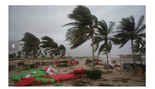
Tropical cyclones are among the most hazardous natural phenomena to coastal communities and infrastructure, producing different destructive effects that can individually cause severe impacts and loss. Their effects and associated detrimental impact include extreme winds, storm surge, intense rainfall (flash flooding) and coastal erosion (Knutson et al. 2010). Recent studies have highlighted a correlation between sea surface rising temperatures with the intensification of tropical cyclone impact (Emanuel 2005) (Figure 1).
Oman has been described as highly vulnerable to the impact of climate change due to anthropogenic and environmental reasons (e.g. Evan et al. 2011; Sultanate of Oman 2013), most prominent of which the increase in the frequency, but also the intensity of cyclones in the past 20 years (Wehner et al. 2019). With projections suggesting further rising of global mean temperatures and the destructive capacity of cyclones (Al-Manji et al. 2021), there is an increasing need for understanding and spatially assessing cyclonic trends and their impact on Oman’s maritime cultural heritage, as well as for mitigating their broader catastrophic effects.
Oman’s Deep Maritime Archaeological Heritage
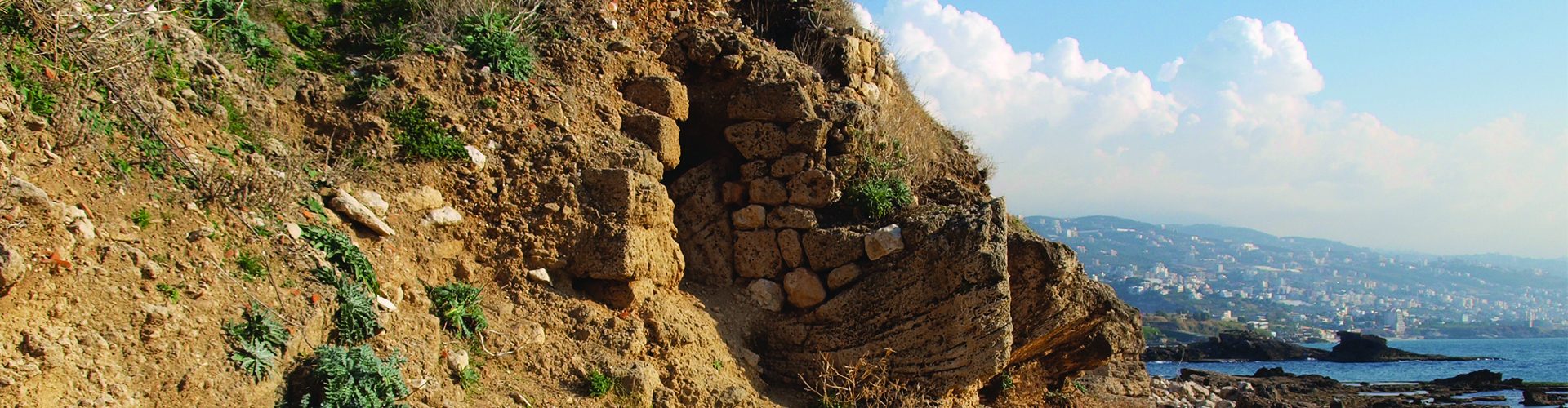
The coastline of Oman has been a desirable area for habitation for various socio-economic and environmental reasons (Giraud 2009). Its coastal aquifers are suitable for agricultural activities, unlike inland locales, where cultivation can be more challenging. Coastal communities in Oman have developed a skilful maritime culture (Staples 2020), which expanded with international maritime activities obtaining a significant role in the maritime trading routes between Africa, India and Europe (Boivin and Fuller 2009). As part of those maritime activities and broader maritime cultural landscapes, a significant number of archaeological remains is found on the coastline of Oman, and many of them on the Arabian Sea, which is a notable cyclone-prone area (Evan and Camargo 2011).
Methodology
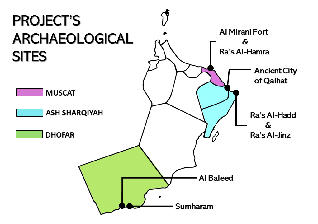
The “Oman Cyclone Activity Project” collected spatial data on the environmental footprint from the highest-impact cyclones from 1889 to 2020 (Table 1) that likely affected Oman’s maritime cultural heritage as documented by the MarEA Project and stored in the EAMENA database (Figure 2).
Cylcone Map Data Sources (tracks and other aftermath data)
| Data Source | Description |
| IBTrACS (International Best Track Archive for Climate stewardship) | Digitised storm tracks and climatic information (wind speed, pressure, rainfall) |
| NOAA (National Oceanic and Atmospheric Administration) – Historic Hurricane Track Mapper | Online map of cyclones affecting Oman between 1881 and 2019. |
| HURSAT (Hurricane Satellite Data) | Digitised storm track of GONU (2007) and 2002 cyclone |
| IMD (India Meteorological Dataset) | Cyclone data inventoried in India’s Governmental Meteorological Department. |
| Al Ruheili et al. (2019) | Academic publication on the impact of the 2002 cyclone in Oman. |
| Al-Hatrushi & Charabi (2010) | Publication of historical data from pre-20th century cyclonic events (tracking and impact data). |
| Membery (2002) | Publication of historical data from pre-20th century cyclonic events (tracking and impact data). |
Through the spatial analysis of impact data such as wind and rainfall, storm surges and shoreline erosion, I identified spatial patterns that highlight the most vulnerable maritime cultural landscapes in Oman (interactive map below). The identification of those landscapes can assist in developing more targeted, frequent and cross-referenced (verified through satellite imagery) assessments on the preservation and protection of each site. The map below shows the highest-impact (>45 kts) cyclonic events from 1889 to 2018, along with their aftermath, as well as information on a selection of archaeological sites.
Map displaying the highest impact (>45 kts) cyclonic events that have affected archaeological sites illustrated in figure 1, in conjunction with documented maritime cultural heritage stored in the EAMENA’s database (October 2021). The map includes each cyclone’s track and aftermath data, such as: Date (Month, Year); Wind speeds (knots); Cyclonic rainfall (mm/24h); Pressure (millibar); Casualties and other relevant information.
Data Analysis
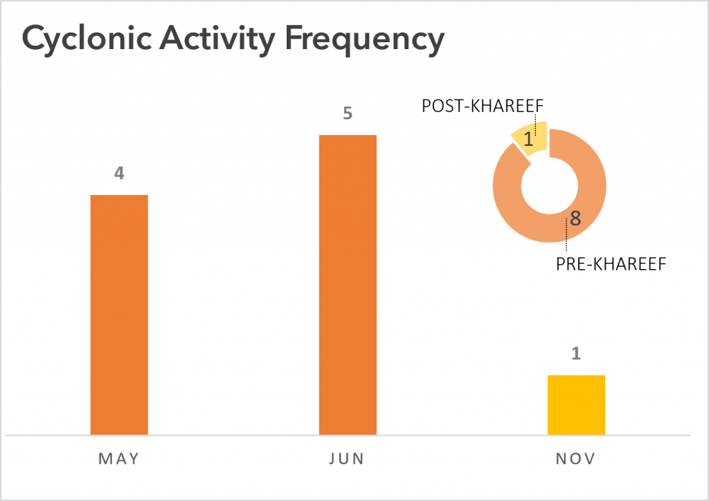
Oman has two main cyclonic seasons: “Pre-Khareef” (May and June) and “Post-Khareef” (September to November). The Khareef season (autumn in Arabic) is a cooler and damp period from the end of June until the end of September affecting the southern part of the Arabian Peninsula. Most of these high-impact cyclonic events seem to occur right before the Khareef Season (May and June) (Figure 3), though cyclones have been documented also in the Post-Khareef period, with a more recent example the October 2021 cyclone affecting Muscat.
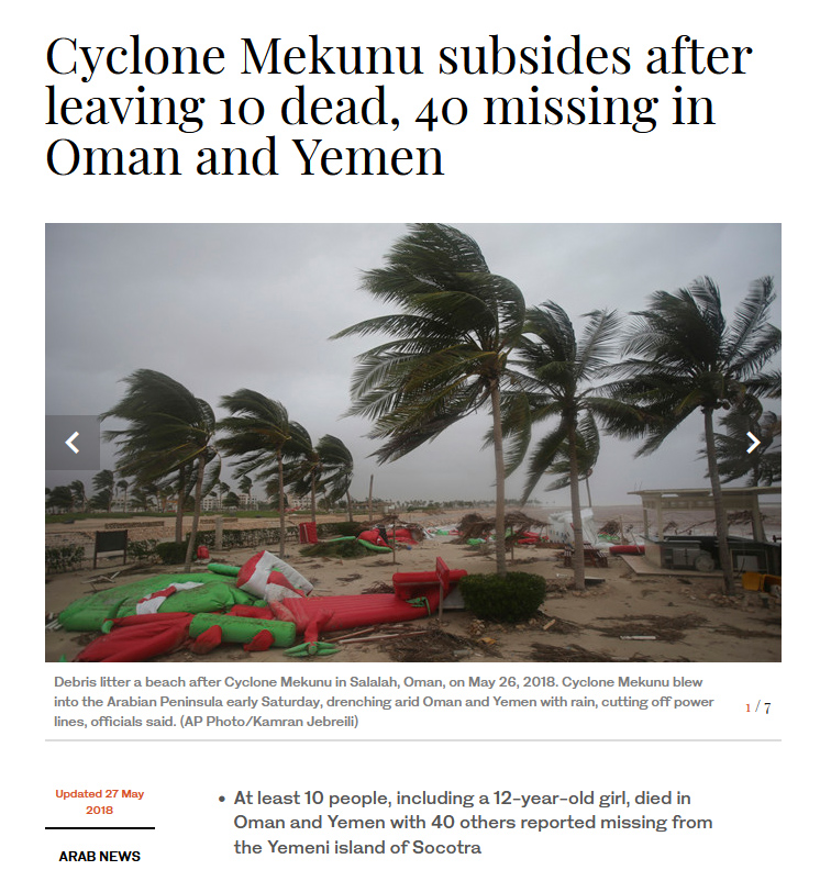
A significant number cyclones concentrate in Dhofar Governorate (southern coast Oman at the border with Yemen) (figure 4). This region has also suffered the strongest winds recorded amongst these cyclonic events, including a maximum of 95 kts (approx. 110 mph) during the Mekunu cyclone (2018), compared to the maximum of 85 kts (approx. 98 mph) registered in the Ash Sharqiyah Governorate during the Gonu cyclone (2007). Though wind intensity within the examined 129-year period demonstrates a certain increase, my study has mainly identified fluctuations rather than a definitive increasing trend (figure 5).
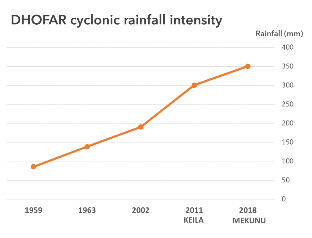
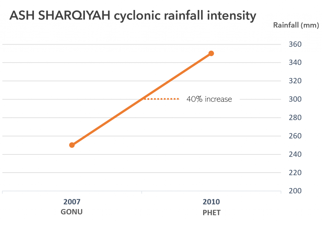
Increasing trends, however, can be discussed more confidently based on data on the volume of cyclonic rainfall (during and after the cyclone event). Tropical cyclones can cause sharply increased precipitation, and potentially develop in dangerous flash flooding or dam overflows, often leading to widespread material damages and loss of human lives. Cyclonic rainfall data from Dhofar demonstrate an increasing curve with a steep raise of 57.9% at the beginning of the 21st century (2002-2011) (Figure 6). Similar observations can be made in Ash Sharqiyah’s rainfall data: even though this area has experienced a lower number and frequency of documented high-impact cyclonic events, in the span of merely three years cyclonic rainfall volume has increased by 40% (figure 7).
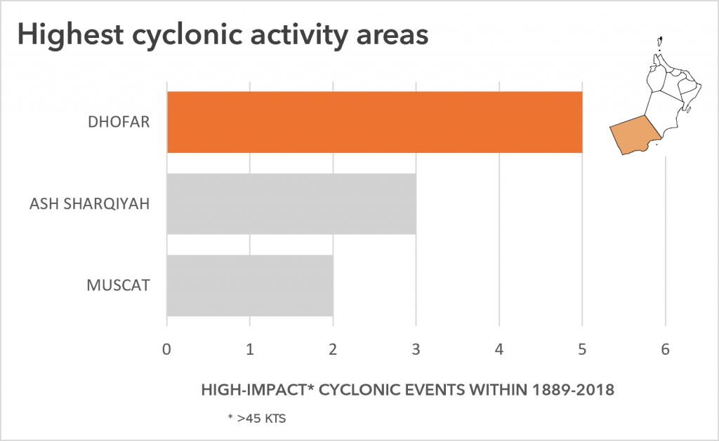
Figure 4.Number of high-impact cyclonic events in Dhofar, Ash-Sharqiyah and Muscat governorates between 1889 and 2018. 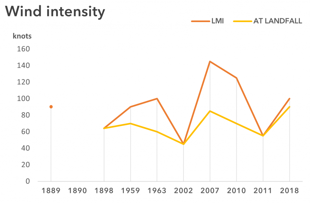
Figure 5. Documented wind intensity of documented cyclonic events between 1889 and 2018.
Discussion
With the prediction of globally rising temperatures, the identification of patterns of cyclone activity has become a key part of damage mitigation and sustainability schemes in coastal countries like Oman. Unfortunately, maritime cultural heritage despite its vulnerability, remains outside of the purview of research and policies on cyclone management.
Among archaeological sites threatened by this increasing environmental hazard, are extensively excavated sites with important evidence for international maritime activity, for example Khor Rori (Sumhuram) and Al-Baleed (Zafar) in the Dhofar Governorate (Newton and Zarins 2019). Both sites are located in an area affected by 55.6% of Oman’s documented cyclones during the past 129 years. We have seen that Oman’s cyclonic season is closely related to the warmest months of the year. This means that both sites have likely experienced the impact of increasing precipitation discussed above, resulting in flooding and coastal erosion. Intense rainfall and flooding can remove sediment and expose previously unknown archaeological features, which may not be documented systematically, if access to the sites is prevented by flooding. Flooding can also severely disturb vulnerable contexts, such as beach burials and other features cut in the sand (e.g. Newton and Zarins 2014: 266). Moreover, coastal erosion can expose and destroy undocumented archaeological features and cause unprecedented damage on contexts at the crucial intersection between the land and the sea. Though the impact of erosion has largely been documented in the eastern coast of Oman (e.g. Al Hatrushi 2013) – a detailed examination of its impact on maritime cultural heritage in Dhofar presents significant opportunities for understanding its relation to cyclonic activity.
Conclusions
This study aimed to present a concrete spatial knowledge of cyclonic activity, as well as areas that need a targeted mitigation strategy toward the forecasted rising cyclone activity. The consequences of climate change and global warming have shown a direct impact on the aftermath of tropical cyclones; rising temperatures are leading to more intense, and more destructive cyclones (Emanuel 2005; Mendelson et al. 2011). Within this context, Oman is directly exposed to this rising environmental threat due to its location in the Arabian cyclonic basin. The exponential curve of Oman’s cyclonic intensity illustrated in this blog shows more than ever a real need of incorporating maritime heritage preservation strategies in governmental schemes of damage mitigation from environmental hazards, with a special focus on the southern region of Dhofar. Delaying its incorporation, could lead to a great loss of Oman’s maritime cultural heritage, and thus, information crucial for the Omani people’s history and culture.
References
Al Ruheili, A., Dahm, R. and Radke, J., 2019. Wadi flood impact assessment of the 2002 cyclonic storm in Dhofar, Oman under present and future sea level conditions. Journal of Arid Environments, 165, pp.73-80.
Al-Hatrushi, S.M. 2013. Monitoring of the shoreline change using remote sensing and GIS: a case study of Al Hawasnah tidal inlet, Al Batinah coast, Sultanate of Oman. Arab Journal of Geosciences 6: 1479–1484. https://doi.org/10.1007/s12517-011-0424-2
Al-Manji, S., G. Mitchell, and A. Al Ruheili 2021. Arabian Sea Tropical Cyclones: A Spatio-Temporal Analysis in Support of Natural Hazard Risk Appraisal in Oman. Agrometeorology. https://doi.org/10.5772/intechopen.96961
Boivin, N. D.Q. = Fuller 2009. Shell middens, ships and seeds: Exploring coastal subsistence, maritime trade and the dispersal of domesticates in and around the ancient Arabian Peninsula. Journal of World Prehistory 22(2:113-180. https://doi.org/10.1007/s10963-009-9018-2
Charabi, Y. and Al-Hatrushi, S., 2010. Indian Ocean tropical cyclones and climate change. Dordrecht: Springer.
Emanuel, K. 2005. Increasing destructiveness of tropical cyclones over the past 30 years. Nature, 436(7051): 686-688.
Evan, A. and S. Camargo 2011. A Climatology of Arabian Sea Cyclonic Storms, 24(1):140-158. https://doi.org/10.1175/2010JCLI3611.1
Evan, A., J. Kossin, C. ‘Eddy’ Chung, and V. Ramanathan 2011. Arabian Sea tropical cyclones intensified by emissions of black carbon and other aerosols. Nature 479(7371): 94-97.
Giraud, J. 2009. The evolution of settlement patterns in the eastern Oman from the Neolithic to the Early Bronze Age (6000–2000 BC). Comptes Rendus Geoscience 341 (8-9):739-749.
Knutson,T.R., J.L. McBride, J. Chan, K. Emanuel, G. Holland, C. Landsea and M. Sugi 2010. Tropical cyclones and climate change. Nature Geoscience 3: 157–163. https://doi.org/10.1038/ngeo779
Membery, D., 2002. Monsoon tropical cyclones: Part 2. Weather, 57(7), pp.246-255.
Newton L.S. and J. Zarins 2014. A possible Indian quarter at al-Baleed in the fourteenth-seventeenth centuries AD. Proceedings of the Seminar for Arabian Studies 44:257-276.
Newton, L.S. and J. Zarins 2019. Dhofar Through the Ages. An Ecological, Archaeological and Historical Landscape. Archaeopress. https://doi.org/10.2307/j.ctvndv7n0
Staples E. 2020 Maritime Heritage in the Sultanate of Oman. In: Parthesius R. and J. Sharfman (eds) Maritime and Underwater Cultural Heritage Management on the Historic and Arabian Trade Routes. Springer, Cham. https://doi.org/10.1007/978-3-030-55837-6_8
Sultanate of Oman: Ministry of Environment & Climate Affairs (MECA), 2013. Initial National Communication under The United Nations Framework Convention on Climate Change. Sultanate of Oman.
Wehner, M.F., C. Zarzyck and C. Patricola 2019. Estimating the human influence on tropical cyclone intensity as the climate changes. In: Collins J. and K. Walsh (eds) Hurricane Risk. Hurricane Risk, vol 1. Springer, Chap: 235-260.