by Azzedine Karra & Athena Trakadas
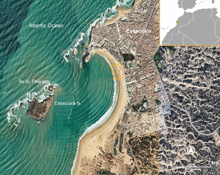
In Morocco, archaeological sites in the coastal zone are becoming more visible due to clearer satellite imagery taken at sometimes very frequent intervals in Google Earth (GE). In several instances, GE imagery extends back almost 20 years. The population of the Morocco MarEA database has been in large part based on analysis of this imagery, but not all sites are visible in it, due to their small size and/or periodic exposure not coinciding with the satellite image captures. Therefore, the collection of Morocco MarEA data has also relied on published surveys/excavations by third parties, previous fieldwork conducted by the authors, and most recently, emergency surveys. This blog highlights the last approach in Essaouira, on the Atlantic coast of Morocco (see the MarEA blog: Essaouira’s Coastal Heritage, Morocco).
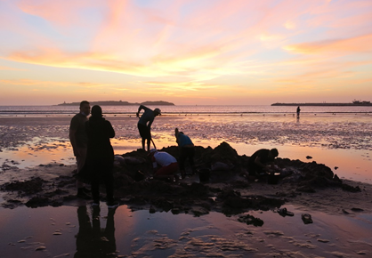
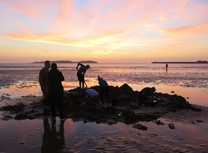
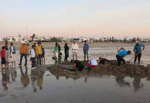
In October 2021, it was possible for the Morocco MarEA team, Azzedine Karra and Athena Trakadas, to conduct a brief emergency survey of a historical shipwreck located in the intertidal zone of the tourist beach in Essaouira. It had been first exposed in October 2018 and naturally re-deposited; it was exposed again in late summer of 2021.
The October fieldwork’s aim was to complete the process of documenting the discovered debris already noted in 2018, in addition to taking samples for analysis. Ultimately, this documentation is to help the responsible Moroccan authorities make a recommendation as to the management of the site. The work was completed due to the kind assistance of Ms. Zhor Amhaouche (Provincial Director of the Ministry of Culture in Essaouira), and Conservators A. Zakaria and Rita Rabouli and the staff of the Sidi Mohammed ben Abdallah Museum in Essaouira.
The amount of sand that had re-covered the wreck since the summer of 2021, in addition to the site’s location in the intertidal zone, made it difficult to fully document the wreck during this year’s campaign of only two days. However, in the end, the documentation was completed in a scientific manner with the required sampling achieved; in addition, a good idea of the nature and components of the ship’s structure was gained.
The site consists of the fragmentary remains of a wooden ship whose length is more than 20 m, and whose keel is oriented perpendicular to the waterline. Some lower frames and a keelson or ceiling or stringer were visible in October 2021. In 2018, a medium-sized iron cannon, fragmentary ceramics, as well as three iron cannon balls and various metal finds had been located nearby (within a 15 m radius). The wreck and these finds had been photographed in situ in 2018; although the cannon remains buried in the beach, the cannon balls, other metal artefacts, and ceramics were recovered in 2018. These finds are undergoing de-salination at the Sidi Mohammed ben Abdallah Museum in the walled medina of Essaouira and were documented there during the 2021 campaign. It is unclear at present whether these loose finds are associated with the wreck site.
During fieldwork, it was estimated that the wreck may date to the end of the eighteenth century or beginning of the nineteenth century. Subsequent C-14 analysis of a wood sample dates the wreck to around the middle of the eighteenth century.
It is unclear as to why the wreck has been exposed and re-deposited only within the last four years. At present, the working hypothesis is that summer storm events, possibly in combination with the recent extension works of the mole and basin of Essaouira port, are affecting currents and near-shore sediment transport in the bay, as well as contributing to scouring on the beach.
Ultimately, recommendations as to the management of the site will require a more in-depth study of the wider marine and geological environment of Essaouira. Photos taken during the wreck’s periods of exposure reveal that the interested public has visited the site when it is exposed, including standing on its structural elements. It is unknown at this time if any smaller artefacts have been illicitly removed.
Dealing with this type of marine archaeological debris distinguished by its presence on the beach, in the intertidal zone, is unprecedented at the national level. The Moroccan authorities are making great efforts to preserve maritime cultural heritage, especially after Morocco signed the UNESCO 2001 Convention on the Protection of the Underwater Cultural Heritage in 2011. With this preliminary investigation, it is hoped that a recommendation for the site’s management can be soon presented. This site will be monitored by the local authorities in Essaouira. Now that the location of the site is pinpointed in GE, the MarEA Morocco team will monitor the site remotely through updated satellite imagery. If exposed again, it might be possible, along with the previous instances of exposure, to identify the causes and exact timing that contribute to the wreck’s exposure and subsequent deposition.
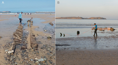
B) in October 2021 (photo: A. Trakadas).